
Pacific Rim Wetlands
Birds, fish, and other species don’t recognize international borders and need wetlands and habitats located in different countries in order to survive. Many of wetland fauna, including some fish species, waterbirds, insects such as butterflies and dragonflies, and mammals such as otters, are migratory species whose conservation and management also require international cooperation.
In addition, many wetlands are systems that lie across the boundaries of two or more countries, or are part of river basins that include more than one country. The health of these wetlands is dependent upon the quality and quantity of the transboundary water supply from rivers, streams, lakes, or underground aquifers. Well managed transboundary water resources increases biodiversity and conservation of natural resources. (From Ramsar: http://www.ramsar.org/cda/en/ramsar-home/main/ramsar/1_4000_0__)
The Pacific Flyway, extending from Alaska to Patagonia, is a 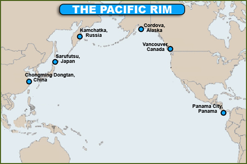 major north-south route of travel for millions of migratory birds. Every year, migratory birds travel some or all of this distance both in spring and in fall, following food sources, heading to breeding grounds, or travelling to overwintering sites. (From Wikipedia http://en.wikipedia.org/wiki/Pacific_Flyway)
Consider the migration of the Pacific Golden-Plover. This species breeds chiefly along the Arctic coast of Siberia and in limited areas of the Alaskan coast. Some of the birds probably migrate south through Asia to winter quarters in Japan, China, India, Australia, New Zealand, and the islands of Oceania. Others go south across the Pacific to Hawaii and other islands in the central and southern Pacific. Migrating golden-plovers have been observed at sea on a line that extends from the Aleutian Islands to Hawaii. While it seems incredible that any birds could lay a course so accurately as to make landfall on these small, isolated, oceanic islands, 2,000 miles south of the Aleutians, 2,000 miles west of Baja California, and nearly 4,000 miles from Japan, year after year Pacific Golden-Plovers make this transoceanic round-trip. (From U.S. Geological Survey: http://www.npwrc.usgs.gov/resource/birds/migratio/routes.htm.)
Some wetlands along the Pacific Rim are particularly notable:
Canada – Fraser River Delta and Boundary Bay, British Columbia
The Fraser River is the longest river in British Columbia, Canada originating in the Rocky Mountains near Mount Robson and flowing for 1400 km (870 mi), into the Pacific Ocean at the city of Vancouver.
The Fraser River is at a critical crossroads along the Pacific Flyway. The paths of many migrant birds converge at the Fraser River Delta. Its location mid-way along the Pacific Coast makes it an international crossroads of bird migration routes from 20 countries and three continents. Waterfowl and shorebirds from breeding grounds in Siberia, Alaska, Yukon, and other arctic and prairie areas all stop to refuel in the Fraser River estuary on their way to wintering grounds in California, Mexico, Central and South America or the South Pacific. 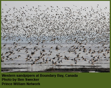
Coastal lowlands and marshes of the estuary provide critical refueling opportunities for long-distance migrants such as the Lesser Snow Goose, which nests in Wrangel Island (Russia) and sometimes makes non-stop flights of over 2,500 km in its southward migration to wintering grounds.
Almost all of the world's population of western sandpipers stop to rest and refuel during their massive migrations between Alaska nesting grounds and wintering sites from California to Peru. In addition, more than 35 other shorebird species rely on this estuary throughout the year.
Green-winged Teal, American Wigeon, Gadwall, Northern Shoveler, Northern Pintail, Lesser Snow Geese, Trumpeter Swans are the most commonly-observed waterfowl species seen inshore. In deeper waters, large rafts of diving ducks such as Greater and Lesser Scaup and Surf Scoters congregate, along with Double-Crested Cormorants, Western Grebes and many species of gulls. Dunlin and Western Sandpipers feed in flocks of thousands on intertidal mudflats, marshes and lowland habitats inland of the dykes. Bald Eagles, Northern Harriers, Red-tailed Hawks, Peregrine Falcons and Short-Eared Owls are just some of the birds of prey to be seen in the river delta. For some species such as the Barn Owl, the delta represents the only site in Canada with mild enough winters for the species to remain year-round.
British Columbia's estuaries are among the richest in the world. The Fraser River is home to over 400 species of vertebrates, thousands of plants, and a myriad of small invertebrates.
The Fraser River forms the largest estuary along the Pacific Coast of North America and drains over 200,000 square kilometers of British Columbia. River sediments meet the currents of the Strait of Georgia and are deposited onto the nearly 30,000 hectares of the estuary's intertidal marshes and mudflats.
The climate is mild, and there are plentiful foods ranging from marine fish and invertebrates to grasses, rodents, and amphibians. Millions of birds all congregate at the mouth of this river, providing a wonderful wildlife viewing spectacle.
The Fraser River is the largest producer of salmon on the entire Pacific Coast of North America. Annually, millions of anadromous (migratory) adult salmon migrate upstream to spawn along small streams along its length and up into the connected waterways. Millions of young fish hatching in these areas spend their early life cycle in these upper reaches, and eventually descend to the estuary on their way out to oceanic habitats. Estuarine marshes, mudflats, floodplains, sloughs and river channels are all critical feeding and rearing areas for these and other fish during their transition between river and marine stages of their life cycle. Pacific Herring, Sturgeon, Eulachon, and Smelt are also abundant fisheries locally, as are Dungeness crab, shrimp and other invertebrates. 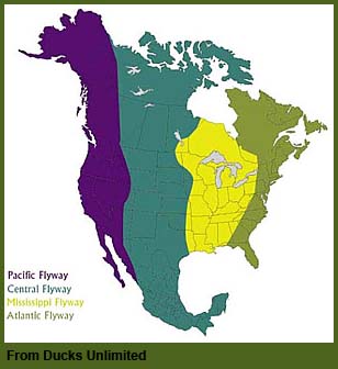
The Fraser River Estuary has received global recognition as a Wetland of International Significance and has been proposed as a WSHRN site. (The abbreviation WSHRN stands for the Western Hemispheric Shorebird Reserve Network, an international initiative to identify and protect habitats in key stopover points used by shorebirds during their long migrations across North and South America (the Western Hemisphere). The Fraser delta ranks very highly, since almost all of the world's population of western sandpipers stop to rest and refuel during their massive migrations between Alaska nesting grounds and wintering sites from California to Peru. In addition, more than 35 other shorebird species rely on this estuary throughout the year.
(From the British Columbia Waterfowl Society: http://www.reifelbirdsanctuary.com/fraser.html)
Japan – Sarufutsu River Wetlands
Sarufutsu Town is located 30-40 km south from Cape Soya, Japan’s northernmost point in Wakkanai city, on the side of the Okhotsk Sea. It comprises a mosaic of lagoons, wetlands, and rivers in the vast wilderness of Sarufutsu and visitors are greeted with its intact nature. There are 6 rivers running through the Sarufutsu wilderness including the Sarufutsu River with their headstreams flowing from Soya Hills. They run gently and windingly into the Sea of Okhotsk due to their small elevation gains up to their upper reaches. Four in those six rivers – the Sarufutsu, Chiraibetsu, Sarusuberi, and Onishibetsu rivers – support the populations of Itou (sea-run taimen).
The Sarufutsu River is inhabited by the largest number of sea-run taimen in Hokkaido and one of the few rivers supporting a stable taimen population. The river slowly flows through wetlands and there is almost no visibility in deep water in its lower reaches. With its grandeur and dynamic flow, this spectacular river is definitely the perfect habitat for Itou, the “Phantom Fish.” Most lagoons in this river system including Poro-numa are connected to the Sarufutsu River and are also habitats for sea-run taimen. (From the Sarufutsu Itou Conservation Council: http://www.sarufutsu-icc.gr.jp/english/rivers_in_sarufutsu_town/revers_in_sarufutsu/index.html)
China
China’s wetlands include 10 percent of all the wetlands in the world. These wetland areas not only are vital to the earth’s ecology but also are attractive places for people for birding and observing other wildlife, fishing (both commercial and recreational), and development of ecotourism and environmental education. Among the many protected wetlands in China, the 21 sites have been designated as Wetlands of International Importance under the Ramsar Convention on Wetlands, joined by China in 1992. The total area of these 21 sites presently covers a surface area of 3.03 million hectares. (From China's 21 Wetlands of International Importance: http://www.china.org.cn/english/TRsummer/73150.htm)
Panama – Panama Bay
Panama is a small Central American country bordered on the northwest by Costa Rica and on the southeast by Columbia. Operation of the Panama Canal, which connects the Atlantic and Pacific oceans, is one of the main industries of the country. Panama's tropical environment supports an abundance of plants and animals.
Every year, the Upper Bay of Panama is visited by as many as two million shorebirds traveling between North and South America via the Isthmus of Panama. Counts of shorebirds along the Panama coast at times exceed 10,000 per kilometer. The site is used by more than 30 percent of the world female population of Western Sandpiper (Calidris mauri) and is globally important for at least six other shorebird species. Based on these high migratory bird counts, the area has been recognized as a Site of Hemispheric Importance by the Western Hemisphere Shorebird Reserve
Network (WHSRN).
Shorebirds are threatened by many factors, including habitat destruction, pollution and human disturbance. More than a quarter of all North America's shorebird species and subspecies are in serious decline, according to WHSRN. Some, such as the New World race of Red Knot (Calidris canutus), will become extinct within present lifetimes if current trends are not halted.
The Upper Bay of Panama is the first site in Central America to join the Western Hemisphere Shorebird Reserve Network (WHSRN), a partnership of organizations working to protect shorebirds and their habitats through a network of key sites across the Americas. Because of its importance to migratory birds, BirdLife identified the bay as an Important Bird Area (IBA) in 2003. It is also on the Ramsar list of wetlands of international importance.
“For the past seven years, the Panama Audubon Society has been working to preserve the wetlands of the Upper Bay of Panama,” said Rosabel Miró, president of the Panama Audubon Society. “The Bay of Panama, which is the first site in Central America to be part of the WHSRN network, is a critical site for migratory shorebirds. Preserving this annual spectacle can only be done through international cooperation, an increasingly obvious requirement for protecting the world’s ecosystems.”
(From BirdLife International
http://www.birdlife.org/news/news/2005/10/panama_bay.html)
Russia – Kamchatka Krai
Kamchatka is recognized as one of the World Wildlife Fund’s Global 200 Ecoregions, due to its globally significant biodiversity. Its ecosystems include arctic and alpine tundra, boreal coniferous forests, temperate deciduous forests, freshwater lake ecosystems, freshwater wetlands, and marine inshore waters.
Russia's 1000-mile long Kamchatka Peninsula contains a vast network of rivers that remain free-flowing from headwaters to ocean and are virtually unaltered by human development. This region produces up to one-fourth of all wild Pacific salmon and hosts the greatest diversity of salmonid species on Earth.
Many of Kamchatka’s rural and indigenous people still rely on salmon for basic needs. Salmon support one in five jobs in Kamchatka and provide food for over 137 species. Kamchatka provides nesting and stopover sites for millions of waterfowl, supports the largest wintering area for Steller’s sea eagles, and hosts the highest brown bear density in the world.
(From United Nations Development Programme: http://www.undp.org/biodiversity/projects_kamchatka.shtml and Wild Salmon Center: http://www.wildsalmoncenter.org/programs/kamchatka/)
United States (Alaska) – Copper River Delta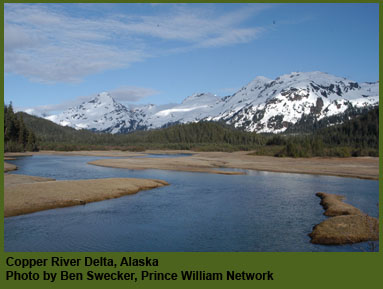
The Copper River winds between the rugged Chugach Mountains and meets the Gulf of Alaska just east of the coastal community of Cordova. Along with the town's remote location, the prized Sockeye and King Salmon that return each year drive the town's economy and give Cordova a unique Alaskan flavor.
The Copper River runs 287 miles through Southcentral Alaska from the headwaters in the Alaska Range to the tidal mudflats bordering the Gulf of Alaska. Linked to five other glacial rivers and their wetlands on the perimeters of the Copper River, the Delta forms the largest continuous wetland on the North Pacific coast.
Tidal flats and sloughs, saltwater marshes, estuaries, freshwater ponds, and waterlogged muskeg (peat soils) of the Copper River Delta compose this vast interwoven wetland of 700,000 acres. The Copper River Delta provides abundant vegetation and endless mud flats for shorebirds and other animals to feast.
Five to seven million shorebirds visit the Copper River Delta every spring. The Delta has 36 species of shorebirds, primarily Western Sandpipers and Dunlins. South of the marshes of the Delta, the tidal mud flats present migrating birds with tasty, energy-rich morsels like pink Macoma clams and marine worms. Some shorebirds remain on the Delta to breed, but most head further north to other Alaskan wetlands. The Copper River Delta is a major stopover site in the western hemisphere, making this wetland a vital link in the chain of wetlands.
In the summer months, "The Copper" carries a million metric tons of sediment each day and dumps it along its meandering journey to the sea. The Copper adds more sediment to the Pacific Ocean than any other source. Six glacial rivers contribute to the Copper River's enormous load, which has formed over thousands of years the 600-foot deep mud flats at its mouth. These mud flats offer shorebirds a feast of mollusks and other invertebrates living beneath the surface.
The Cordova Ranger District of the U.S. Forest Service manages this magnificent wetland habitat primarily for fish and wildlife. The savored salmon runs of the Copper River depend on the cold, silty waters as a highway to the streams where they hatched and will lay the eggs of the next generation. In addition, brown bear, black bear, moose, wolves, coyotes, mountain goat, sheep, Stellar sea lions, trumpeter swans, and three species of amphibians make the Copper River Delta their home.
(From Migration Science and Mystery: A Distance Learning Adventure: http://migration.pwnet.org/stopovers/cordova_where.php)